
Yellowstone National Park: Guide & Itineraries
Jim Peaco, National Park Service (Public Domain)
State
Wyoming / Montana / Idaho
Best season
Summer
Entrance fee
$35 per vehicle (7-day pass)
The world's largest geothermal area, a supervolcano caldera, and one of North America's best wildlife corridors — all in one park spanning 3,500 square miles across Wyoming, Montana, and Idaho.
Established in 1872 as the world's first national park, Yellowstone sits atop one of Earth's largest active volcanic systems. The park contains more than 10,000 geothermal features — over half the world's geysers — alongside dense forests, alpine lakes, and one of the continent's most intact large-mammal ecosystems.
The park spans three states and five entrances. The Grand Loop Road — a figure-eight of roughly 140 miles — connects all major areas and can be driven in a day, but that misses nearly everything. Four days is the realistic minimum for a quality visit. Three days leaves the park feeling like a checklist; with four, you have time to slow down in Hayden Valley, spend a full dawn in Lamar Valley, and actually see wildlife rather than just driving past the opportunity.
The 4-Day Plan below covers the park's four distinct zones: the geyser basins (Days 1), the Grand Canyon and wildlife valleys (Day 2), the upper loop and hot spring terraces (Day 3), and a full dedicated wildlife day in Lamar Valley (Day 4). Consider staying in two different locations — Old Faithful area for Days 1–2, Canyon Village or Tower area for Days 3–4 — to avoid long daily drives.
Day 1: Geyser Basins — West & South Loop
Start: West Entrance. End: West Thumb Geyser Basin on Yellowstone Lake. Driving: ~60 miles. Walking: 3–5 miles on boardwalks.
| # | From → To | Mode | Distance / Time | Notes |
|---|---|---|---|---|
| 1 | West Entrance → Madison Junction | Drive | 14 mi / 25 min | Madison River corridor; bison and elk frequent the roadside |
| 2 | Madison → Old Faithful area | Drive | 16 mi / 30 min | Check next predicted eruption time at the visitor center on arrival |
| 3 | Old Faithful → Upper Geyser Basin loop | Walk | 2.5 mi loop / 1.5 hrs | Morning Glory Pool, Castle Geyser, Riverside Geyser — most visitors skip this entirely |
| 4 | Old Faithful → Midway Geyser Basin | Drive + walk | 5 mi / 45 min | Grand Prismatic Spring boardwalk; add 1-mi Fairy Falls trail for the aerial view |
| 5 | Midway → West Thumb Geyser Basin | Drive | 17 mi / 30 min | Geysers and hot springs on the shoreline of Yellowstone Lake |
Map tiles © OpenStreetMap contributors
Morning (7:00am – 12:00pm)
- 7:00am — West Entrance: Arrive early before the queue builds. The 14-mile drive to Madison Junction follows the Madison River; bison herds are common along the banks.
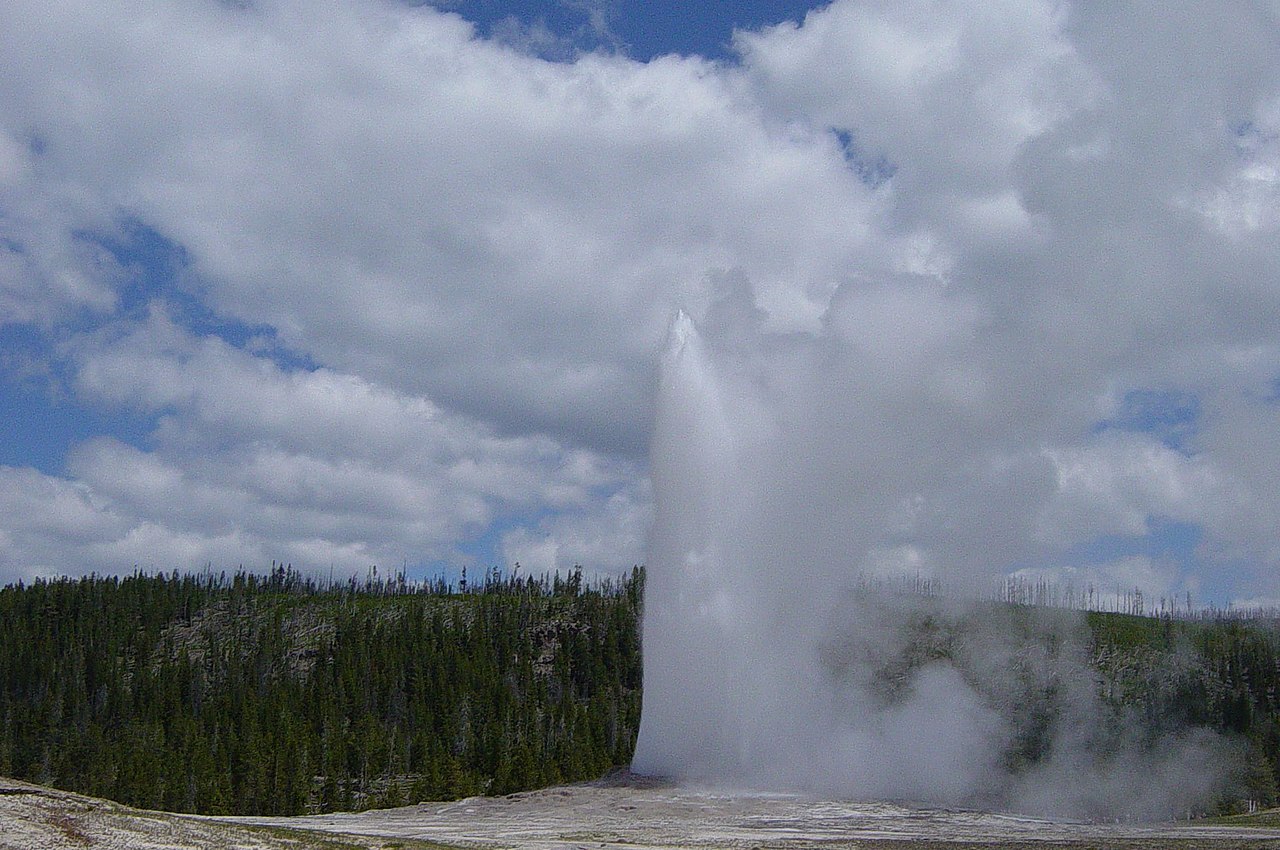
- 8:00am — Old Faithful: Check the predicted eruption time at the visitor center. Eruptions occur every 60–110 minutes and last 1.5–5 minutes. While waiting, walk the Upper Geyser Basin boardwalk loop (2.5 miles) — most visitors sit at the bleachers and miss Morning Glory Pool, Castle Geyser, and Riverside Geyser, which are often more visually interesting than the main event.
- 10:00am — Midway Geyser Basin: Grand Prismatic Spring (largest hot spring in the US) is vivid from the boardwalk, but the full concentric-ring pattern is only visible from above. Take the Fairy Falls overlook trail (about 1 mile from the trailhead) for the aerial perspective — the orange, green, and blue rings are far more dramatic from height.
Afternoon (12:00pm – 6:00pm)
- 1:00pm — Lower Geyser Basin (optional): The Fountain Paint Pot boardwalk (0.5 miles) covers bubbling mud pools, fumaroles, and several active geysers in 30–45 minutes. Less crowded than Old Faithful at any hour.
- 2:30pm — West Thumb Geyser Basin: Drive south on the Grand Loop Road to the western shore of Yellowstone Lake, where hot springs and geysers emerge directly from the lakeshore. The Absaroka Range is visible across the 20-mile-wide lake on clear days. The contrast of thermal activity beside cold lake water is unusual.
- Evening: Stay at Old Faithful Inn (the 1904 log-and-timber lodge is one of the great national park buildings) or drive to Canyon Village for the next morning's early start.
Day 2: Grand Canyon of the Yellowstone + Hayden Valley
Start: Canyon Village. End: Mud Volcano / Yellowstone Lake area. Driving: ~15 miles. Walking: 2–4 miles.
| # | From → To | Mode | Distance / Time | Notes |
|---|---|---|---|---|
| 1 | Canyon Village → Artist Point (South Rim) | Drive + short walk | 2 mi / 20 min | Classic overlook of the Lower Falls (308 ft) and 1,000 ft yellow-and-orange canyon walls |
| 2 | Artist Point → Uncle Tom's Trail | Walk | 0.5 mi / 30 min | 328 stairs descend to a spray-soaked platform at the base of the Lower Falls |
| 3 | South Rim → Inspiration Point (North Rim) | Drive + walk | 3 mi / 20 min | Different downstream angle; walk the North Rim Trail toward Brink of Lower Falls overlook |
| 4 | Canyon → Hayden Valley | Drive (very slow) | 8 mi / 30–60 min | Stop at every pullout; bison herds, grizzly bears, sandhill cranes, river otters |
| 5 | Hayden Valley → Mud Volcano | Drive + walk | 4 mi / 30 min | Dragon's Mouth Spring and Mud Caldron boardwalk (~0.5 mi loop) |
Map tiles © OpenStreetMap contributors
Morning (7:00am – 12:00pm)
- 7:00am — Artist Point: The South Rim viewpoint for the Grand Canyon of the Yellowstone. The Lower Falls drop 308 feet — nearly twice Niagara — into a canyon of yellow and orange rhyolite. Morning light hits the canyon wall directly. Uncle Tom's Trail descends 328 stairs to a steel platform within the mist of the falls — the only way to fully understand the scale.
- 9:00am — North Rim: Drive across to Inspiration Point and the Brink of the Lower Falls trail (0.5 miles, steep) for an upstream view directly over the edge.
- 10:30am — Canyon Lodge: Breakfast or early lunch before heading south into Hayden Valley.

Afternoon (12:00pm – 6:00pm)
- 12:00pm — Hayden Valley: The 8-mile drive south from Canyon Village through this broad grassland is the park's most reliable wildlife corridor. Drive at walking speed and stop at every pullout. Bison herds of hundreds can stop traffic for 20 minutes. Grizzly bears appear on the valley slopes, particularly in early morning and late afternoon; sandhill cranes, trumpeter swans, and river otters are regularly seen from the Yellowstone River banks. The best tactic is to stop wherever other cars are stopped — someone has a scope pointed at something worth seeing.
- 3:00pm — Mud Volcano: A short but striking boardwalk loop through one of the park's most acidic thermal areas. Dragon's Mouth Spring churns from a cave opening with a rhythmic thumping sound; Mud Caldron bubbles continuously. The sulfur smell is significant.
- Evening: Sunset from Yellowstone Lake (Lake Village) or drive north to Tower-Roosevelt for Day 3.

Day 3: Upper Loop — Norris, Mammoth, Tower
Start: Canyon Village / Norris area. End: Tower-Roosevelt Junction. Driving: ~55 miles along the upper half of the Grand Loop. Note: This day covers the park's northern arc, setting up for an early departure into Lamar Valley on Day 4.
| # | From → To | Mode | Distance / Time | Notes |
|---|---|---|---|---|
| 1 | Canyon → Norris Geyser Basin | Drive | 12 mi / 20 min | Park's hottest, most dynamic basin; Porcelain Basin loop (0.75 mi) is the highlight |
| 2 | Norris → Mammoth Hot Springs | Drive | 21 mi / 35 min | Drive through the Gardner River canyon; elk graze the Mammoth lawns year-round |
| 3 | Mammoth Hot Springs terraces walk | Walk | 1–2 mi boardwalk / 1 hr | Upper and lower terrace drives cover different formations; Liberty Cap and Palette Spring |
| 4 | Mammoth → Tower-Roosevelt Junction | Drive | 18 mi / 30 min | Stop at Undine Falls pullout (60-ft waterfall); pronghorn on open sagebrush flats |
| 5 | Tower-Roosevelt area | Short walk or rest | — | Roosevelt Lodge dinner; Petrified Tree (0.5 mi) is a short detour; sleep here for Day 4 |
Map tiles © OpenStreetMap contributors
Morning (7:00am – 1:00pm)
- 7:00am — Norris Geyser Basin: The park's hottest and most geologically active basin — Steamboat Geyser, the world's tallest active geyser, erupts here unpredictably (intervals of days to years; check current activity before arrival). The Porcelain Basin loop (0.75 miles) winds through a dense cluster of pools, vents, and small geysers in a stark pale landscape. Significantly less crowded than Old Faithful at any time.
- 9:30am — Mammoth Hot Springs: Drive 21 miles north through the Gardner River canyon to the park's northern hub. The travertine terraces here are completely unlike the silica-based geothermal features elsewhere in the park — calcium carbonate deposits form layered white-and-orange platforms that grow and change shape seasonally. Walk both the Upper and Lower terrace loops (1–2 miles total). Elk graze the lawns around the historic fort buildings year-round; in fall, bull elk bugle from the parking lots.

Afternoon (1:00pm – 6:00pm)
- 1:30pm — Drive to Tower-Roosevelt: The 18-mile road east from Mammoth passes through open sagebrush flats where pronghorn are commonly visible. Stop at Undine Falls (a 60-foot cascade visible from a short roadside trail) and the Petrified Tree — a standing fossilized redwood from 50 million years ago, preserved upright in the hillside.
- 3:00pm — Tower-Roosevelt: The least-visited of the major park hubs, Roosevelt Lodge retains a frontier atmosphere. This is the staging point for Day 4's Lamar Valley dawn. Sleep here (Roosevelt Lodge cabins, or camping at Tower Fall Campground) to minimize morning drive time into the valley.
- Evening: The Tower Fall area (0.5 miles from the junction) has a 132-foot waterfall visible from a viewpoint above the plunge pool. A steep trail descends to the base.
Day 4: Lamar Valley — Full Wildlife Day
Start: Tower-Roosevelt Junction at first light. Focus: Wolves, bears, bison, pronghorn. Essential gear: 10× binoculars or a spotting scope. Key principle: Stop wherever other cars are stopped — someone is watching something.
| # | Stop / Activity | Time | Notes |
|---|---|---|---|
| 1 | Tower-Roosevelt → Lamar Valley (drive slowly) | 5:00–6:00am | First light is the most productive window; wolf packs move before full sunrise |
| 2 | Lamar Valley west pullouts | 6:00–9:00am | Large bison herds; wolves and coyotes active on valley floor and lower slopes |
| 3 | Lamar Valley main corridor (Confluence area) | 9:00–11:00am | Lamar River–Soda Butte Creek confluence; frequent bear sightings on the far ridgeline |
| 4 | Soda Butte Creek area | 11:00am–1:00pm | Eastern end of the valley; pronghorn, raptors, Soda Butte Cone geothermal feature |
| 5 | Afternoon return + second wildlife session | 4:00–7:00pm | Late afternoon is the second-best wildlife window; return to any morning location |
Map tiles © OpenStreetMap contributors
Dawn (5:00am – 9:00am)
- 5:00am — Depart Tower-Roosevelt: The 10-mile drive from Tower to the Lamar Valley corridor should be done at walking speed with the windows down, scanning the slopes on both sides. Wolf packs — reintroduced here in 1995 — are most active in the first hour of light. The Lamar Valley has been called "America's Serengeti" for the density and diversity of large mammals visible from the road.
- 6:00am — West pullouts: The first set of roadside pullouts overlooks open flats where bison herds of 50–500 animals are common. Coyotes hunt the meadow edges. Stop anywhere cars are gathered — the park's volunteer "wolf watchers" and wildlife biologists are often stationed at these spots and will share their scopes and knowledge freely.
- 8:00am — Confluence area: Where Soda Butte Creek meets the Lamar River, the valley briefly narrows. Grizzly bears are frequently spotted on the ridgelines here, particularly in late spring and early summer when bears forage for roots and ground squirrels on the open slopes. River otters use this stretch of the Lamar River.

Midday rest + afternoon return (1:00pm – dusk)
- 1:00pm — Midday lull: Wildlife activity drops significantly between 10am and 4pm as animals seek shade. Use this time to return to Tower-Roosevelt for lunch, rest, or a short hike to Lost Lake (3-mile loop from the lodge).
- 4:00pm — Second session: Return to Lamar Valley for the late afternoon window. The same locations that were productive in the morning will often be active again. Bring warm layers — the valley cools quickly after sunset even in summer.
- What to look for: Wolves are most reliably spotted in the Druid Peak and Wapiti Lake pack territories. Black and grizzly bears are both present — grizzlies are distinguished by the shoulder hump and dished face. Pronghorn (the fastest animal in North America) are common on the open flats near Soda Butte. Bison calves are born in May and early June.
Wildlife safety: Maintain at least 25 yards from bison and elk, 100 yards from bears and wolves at all times. Bison cause more injuries in Yellowstone than any other animal and can sprint at 35 mph despite appearing slow. Never position yourself between a bear and cubs, or between any animal and its escape route.
Key Highlights
- Old Faithful & Upper Geyser Basin — Iconic eruption, but walk the full 2.5-mile basin loop to see what most visitors miss.
- Grand Prismatic Spring — Largest hot spring in the US; Fairy Falls overlook trail shows the full color rings from above.
- Grand Canyon of the Yellowstone — 1,000-foot deep, 308-ft Lower Falls. Uncle Tom's Trail gets you inside the spray zone.
- Hayden Valley — Most reliable large mammal sightings: bison, grizzly, river otter, sandhill crane. Drive slowly.
- Norris Geyser Basin — The park's hottest, most dynamic basin. Less crowded than Old Faithful and more geologically active.
- Lamar Valley — The best place in the contiguous US to see wolves in the wild. Requires patience and early mornings. Bring optics.
Planning Notes
- Minimum days: Four days is the realistic minimum for a quality Yellowstone experience. Three days covers the highlights but feels rushed; the park rewards slowing down, especially in Hayden and Lamar valleys.
- Two-location strategy: Stay near Old Faithful for Days 1–2, then move to Tower-Roosevelt area for Days 3–4. This eliminates the 50–60 mile daily commute between the park's two main zones.
- Lodging: Seven lodges inside the park; book 13 months in advance for summer. Old Faithful Inn (1904) and Roosevelt Lodge are the most atmospheric. Gateway towns (West Yellowstone, Gardiner, Cooke City) have additional options.
- Cell service: Essentially nonexistent inside the park. Download the NPS Yellowstone app and offline maps before entering.
- Road construction: Grand Loop sections are under repair most summers. Check nps.gov/yell for current closures before departure.
- America the Beautiful Pass ($80): Covers entrance to all federal lands for one year — worthwhile if visiting more than two parks.
Keep exploring

Grand Canyon National Park: Complete Visitor Guide & Itineraries
277 miles long, up to 18 miles wide, and over a mile deep — the Grand Canyon is one of the most visited natural landmarks in the world and one of the best preserved geological records on Earth. This guide covers rim viewpoints, inner-canyon hikes, 1- to 3-day itineraries, and detailed route planning for first-time visitors.
Great Smoky Mountains National Park: Guide & Itineraries
The most visited national park in the United States — and the only major one with no entrance fee — spanning 522,000 acres of ancient Appalachian forest across the Tennessee–North Carolina border.

Yosemite National Park: Guide & Itineraries
A glacially carved granite valley in the Sierra Nevada, home to some of North America's tallest waterfalls, sheer rock faces that define modern climbing, and one of the largest groves of ancient giant sequoias.