Zion National Park: Guide & Itineraries
National Park Service (Public Domain)
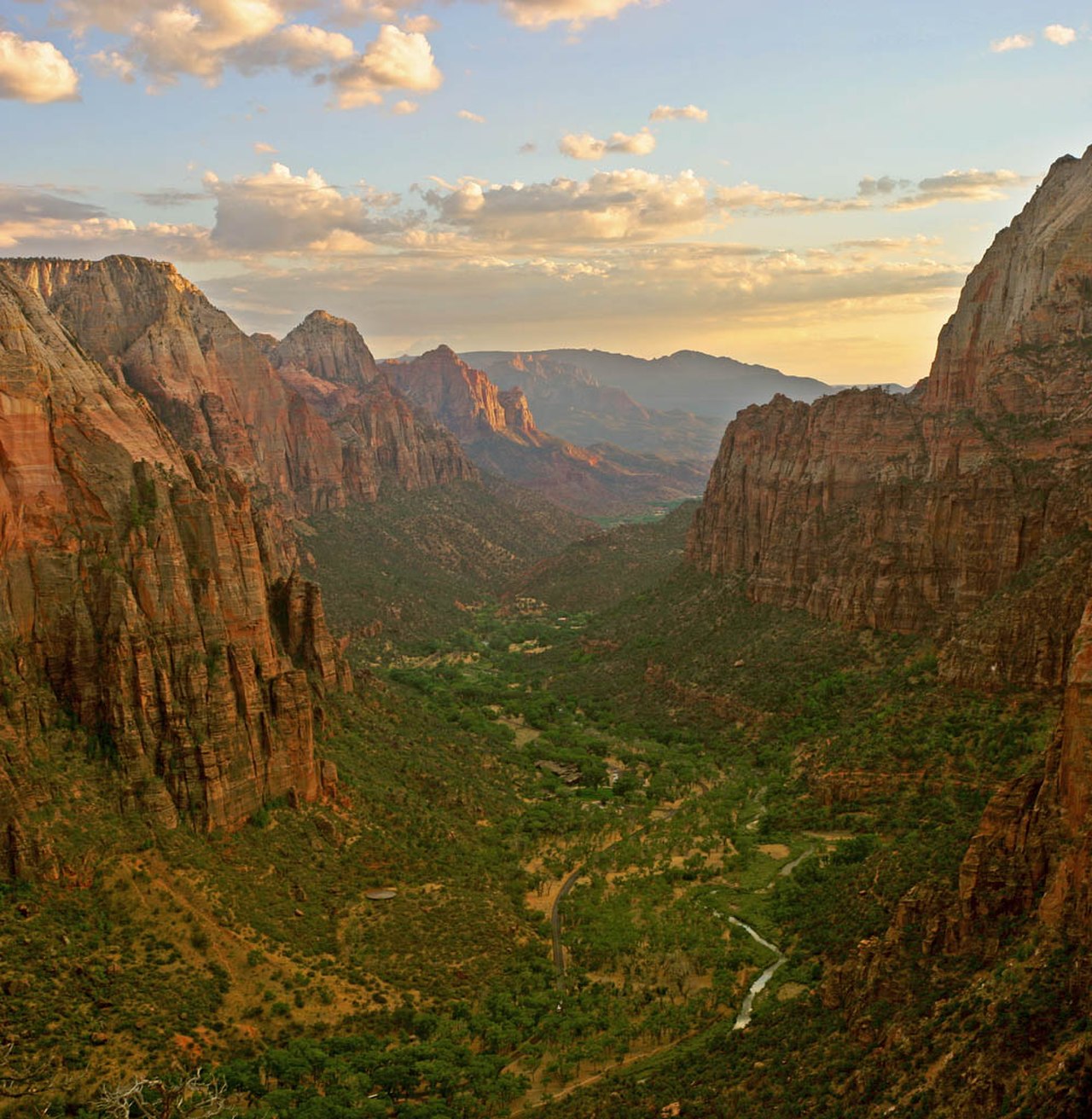
A narrow canyon of Navajo Sandstone walls rising 2,000 feet from the floor of the Virgin River in southern Utah — one of the most visited national parks in the United States.
Zion Canyon was carved by the Virgin River cutting through layers of Navajo Sandstone over millions of years. The canyon walls rise up to 2,000 feet above the valley floor, and the rock changes color through the day — pale pink at dawn, nearly white at midday, deep coral-orange at sunset.
The park has two distinct sections. Zion Canyon is the main gorge, with the shuttle system, the major hikes, and most of the infrastructure. Kolob Canyons, accessible from a separate entrance off Interstate 15 about 40 minutes northwest, offers a dramatically different landscape with almost no crowds. From late March through November, the Zion Canyon Scenic Drive is closed to private vehicles — the free park shuttle is the only way up the canyon during this period.
Zion's two essential experiences — The Narrows and Angels Landing — each deserve a full day. Two days is the right amount of time for most visitors: one day per marquee hike, with the canyon shuttle stops woven around them. If you have a third day, Kolob Canyons (40 minutes northwest, separate entrance) offers dramatically different red-and-white canyon walls with almost no crowds.
Day 1: The Narrows + Canyon Shuttle Stops
Start: Zion Visitor Center (shuttle stop 1). End: Temple of Sinawava / Narrows entrance. Walking: 2–5 miles (more if wading into the Narrows). Gear: Rent waterproof boots and neoprene socks in Springdale the night before if planning a serious Narrows wade.
| # | Stop | Mode | Distance / Time | Notes |
|---|---|---|---|---|
| 1 | Visitor Center → Court of the Patriarchs | Shuttle (stop 4) | 15 min shuttle | Three towering sandstone peaks; short viewpoint walk from the stop |
| 2 | Court of Patriarchs → Zion Lodge | Walk or shuttle | 0.8 mi walk | Lunch, restrooms, water refill; book the Red Rock Grill in advance |
| 3 | Zion Lodge → Weeping Rock | Shuttle (stop 7) | 0.4 mi trail / 30 min | Spring-fed alcove dripping with water; hanging gardens of maidenhair fern |
| 4 | Weeping Rock → Temple of Sinawava | Shuttle (stop 9) | End of canyon road | Walk the 2-mile paved Riverside Walk to the Narrows entrance |
| 5 | Narrows wade (in-river, optional) | Walk in river | Go as far as desired | Knee-to-waist deep; walls close to 20 ft across in places; check flash flood status daily |
Map tiles © OpenStreetMap contributors
Morning (7:00am – 12:00pm)
- 7:00am — Board early shuttle: The first shuttles fill quickly in summer. Arrive at the visitor center early and board before the main crowd. The canyon road is 6.5 miles long; the shuttle makes eight stops.
- 7:30am — Court of the Patriarchs (stop 4): Three massive sandstone peaks — Abraham (6,990 ft), Isaac (6,823 ft), and Jacob (6,831 ft) — named by Methodist minister Frederick Fisher in 1916. The short viewpoint trail offers an unobstructed look at all three from below.
- 8:30am — Zion Lodge (stop 5): The only in-canyon lodging. The Red Rock Grill serves breakfast. Refill water here before heading to the upper canyon.
- 9:30am — Weeping Rock (stop 7): A 0.4-mile paved trail climbs to a dripping alcove fed by groundwater seeping through the sandstone. Hanging gardens of maidenhair fern and columbine cling to the wet wall. The canyon view from the alcove is excellent.

Afternoon (12:00pm – 5:00pm)
- 12:00pm — Temple of Sinawava (stop 9): The end of the canyon road, named after the coyote spirit of the Southern Paiute people. A large amphitheater of orange-and-white stone walls surrounds the river bend.
- 12:30pm — Riverside Walk: A 2-mile paved round-trip trail follows the Virgin River to the Narrows entrance. The canyon walls close in progressively — by the end, they rise hundreds of feet above and are only a few yards apart. This section is accessible to all.
- 1:30pm — The Narrows: Beyond the Riverside Walk, hikers step into the Virgin River and continue upstream. The canyon averages 20–30 feet wide in the most dramatic sections, with walls towering 1,000 feet above. You can wade in for 20 minutes or commit to hours. The water is knee-to-waist deep; river shoes are mandatory (regular trail shoes are dangerously slippery on wet river rock). Check the NPS Narrows status report before starting — flash floods can occur with zero warning from rain upstream.
- 4:00pm — Pa'rus Trail: Return shuttle to the visitor center, then walk the Pa'rus Trail (3.5 miles one-way along the Virgin River, paved, accessible) for a relaxed end to the day.

Day 2: Angels Landing + Canyon Overlook
Start: The Grotto trailhead (stop 6). Angels Landing: 5.4 mi round-trip, 1,488 ft gain. Permit required for the final chain section above Scout Lookout. Afternoon: Canyon Overlook Trail on the east side of the Zion-Mount Carmel Tunnel.
| # | From → To | Mode | Distance / Time | Notes |
|---|---|---|---|---|
| 1 | Grotto TH → Refrigerator Canyon | Hike (moderate) | 1 mi / 40 min | Shaded section through a narrow side canyon; temperatures noticeably cooler |
| 2 | Refrigerator Canyon → Walter's Wiggles | Hike (steep) | 0.5 mi / 30 min | 21 short switchbacks blasted into the cliff; the most strenuous section |
| 3 | Walter's Wiggles → Scout Lookout | Hike | 0.2 mi / 15 min | Last safe stopping point; good views without the chain section. Permit required beyond here. |
| 4 | Scout Lookout → Angels Landing summit | Hike (chains, exposed) | 0.5 mi / 45–60 min | Fixed chains on 1,000-ft drop-off ridge; not recommended for those with fear of heights |
| 5 | Canyon Overlook Trail (afternoon) | Hike | 1 mi round-trip / 45 min | East side of the Zion-Mt Carmel Tunnel; views of the Great Arch; far less crowded |
Map tiles © OpenStreetMap contributors
Morning (6:30am – 12:00pm)
- 6:30am — The Grotto trailhead: Start no later than 7am. The chain section becomes extremely crowded by mid-morning, turning a thrilling scramble into a slow queue. Early starts avoid both the crowds and the midday heat on the exposed ridge.
- 7:00am — Refrigerator Canyon: The first mile of the trail winds through a shaded slot between canyon walls. The air is noticeably cooler here; enjoy it before the sun reaches the exposed sections above.
- 7:40am — Walter's Wiggles: Twenty-one short, tight switchbacks carved into the cliff face. This is the most aerobically demanding part of the hike — steady pace, small steps, don't rush.
- 8:00am — Scout Lookout: A broad sandy saddle with 180-degree canyon views. This is a satisfying destination in its own right if you don't have a permit or prefer not to do the chain section. The drop-offs below are already striking from here.
- 8:30am — Angels Landing summit (permit required): The final 0.5 miles uses fixed chains bolted into a narrow sandstone fin with 1,000-foot drops on both sides. The summit view encompasses the full length of Zion Canyon from 1,488 feet above the Virgin River. Take your time on the descent — most accidents happen coming down.

Afternoon (12:00pm – 5:00pm)
- 12:00pm — Lunch at Zion Lodge: Return shuttle to Zion Lodge for food and rest. Afternoon on the exposed Angels Landing trail is not recommended in summer — temperatures on the ridge can exceed 100°F.
- 2:00pm — Canyon Overlook Trail: Drive east through the park (Zion-Mount Carmel Highway), a scenic road that passes through a mile-long tunnel and switchbacks up the canyon wall. The Canyon Overlook trailhead is immediately east of the tunnel exit. This 1-mile round-trip hike (45 minutes, moderate) ends at a viewpoint over the Great Arch and the lower canyon — a completely different perspective than the canyon floor. Far fewer people than any canyon shuttle stop.
- 4:00pm — East side exploration: Continue east of the tunnel for the checkerboard mesa formations and slickrock terrain — very different geology than the main canyon. Return to Springdale for the evening.
Angels Landing permit: The recreation.gov lottery has two tracks. The seasonal lottery opens months ahead for the following season; the day-before lottery opens at 3pm the day prior with results at 5pm. Only the final chain section above Scout Lookout requires a permit — the rest of the hike up to Scout Lookout is open without one.
Key Highlights
- The Narrows — The Virgin River slot canyon; wade upstream as far as you want. Rent waterproof boots in Springdale. Check flash flood status daily.
- Angels Landing — 1,488 ft above the canyon floor via a chain-assisted ridge walk. Permit required above Scout Lookout. Start before 7am.
- Emerald Pools — Three pools fed by desert springs, connected by trails of increasing difficulty. Good family option or a lighter half-day.
- Canyon Overlook Trail — 1 mile, east side of the tunnel, views of the Great Arch. Dramatically less crowded than any canyon-floor trail.
- Kolob Canyons — 40 min northwest via I-15, separate entrance, same 7-day pass. Red-and-white canyon walls, Taylor Creek Trail (5 mi round-trip to Double Arch Alcove), almost no crowds. Worth a third day if you have the time.
Planning Notes
- Angels Landing permit: Required above Scout Lookout. Two lottery tracks at recreation.gov: seasonal (months ahead) and day-before (results at 5pm). Scout Lookout itself is open without a permit and is a great destination on its own.
- Narrows flash floods: Check the park's daily Narrows status at nps.gov/zion. Rain upstream — even with no rain at the canyon — can cause rapid flooding. Never enter the Narrows when the status is "not recommended."
- Gear rental: Waterproof boots and neoprene socks are available from multiple shops in Springdale. Rent the night before to get an early start. Regular trail shoes are dangerously slippery on wet river rock.
- Shuttle: Late March through November, no private vehicles are allowed on the canyon scenic drive. The free shuttle runs from the visitor center every 6–10 minutes in peak season. In Springdale, a separate free town shuttle connects to the park.
- Best seasons: Spring (March–May) for waterfalls and green vegetation. Fall (September–November) for warm days and thinner crowds. Summer is very hot on exposed ridges — start all hikes before 8am. Winter is mild at canyon level with occasional snow on upper trails.
Keep exploring

Grand Canyon National Park: Complete Visitor Guide & Itineraries
277 miles long, up to 18 miles wide, and over a mile deep — the Grand Canyon is one of the most visited natural landmarks in the world and one of the best preserved geological records on Earth. This guide covers rim viewpoints, inner-canyon hikes, 1- to 3-day itineraries, and detailed route planning for first-time visitors.
Great Smoky Mountains National Park: Guide & Itineraries
The most visited national park in the United States — and the only major one with no entrance fee — spanning 522,000 acres of ancient Appalachian forest across the Tennessee–North Carolina border.

Yellowstone National Park: Guide & Itineraries
The world's largest geothermal area, a supervolcano caldera, and one of North America's best wildlife corridors — all in one park spanning 3,500 square miles across Wyoming, Montana, and Idaho.